Europe in winds

Full size image (4 Mb), Video (143 Mb)
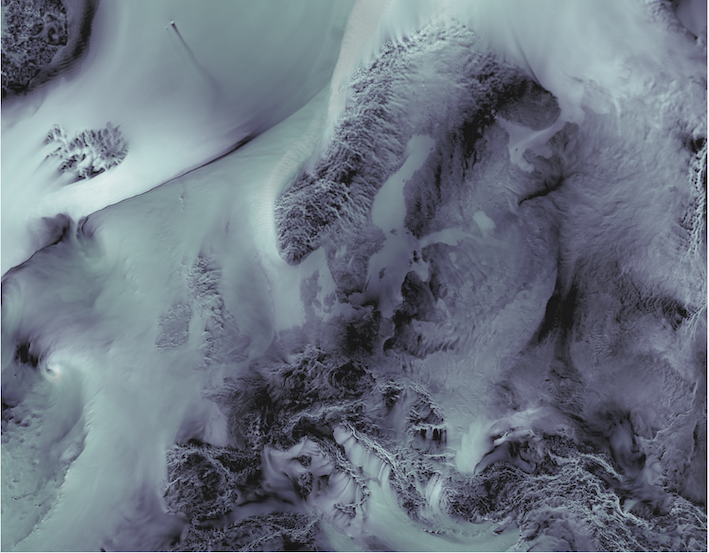
Wind gusts over Europe as simulated by coupled climate model with 4km spatial resolution in the atmosphere.
This image won 1st Place at Helmholtz Best Scientific Image Contest 2022.
The Image shows wind gusts over Europe as simulated by a next-generation climate model with 4km spatial resolution in the atmosphere. Those simulations, performed on world’s largest supercomputers in the context of the EU Horizon2020 project NextGEMS, are part of the efforts to create Digital Twins of the Earth, including coupled atmosphere ocean models with very high spatial resolution, that will allow breakthroughs in our understanding of the functioning of the climate system along with its changes in a warming world – in support of evidence-based decision-making.
This figure shows results of the model run that uses twice the resolution typically used for weather prediction and runs for a longer time (several months). Wind gusts are overlayed by the x-component of the wind for shading, which is plotted in gray-scale and made transparent. There is no explicit plotting of land, the high resolution allows for the land to “shine through” due to larger surface friction and hence smaller wind speeds. The darker the area the smaller the wind is. This particular image have several interesting features: (i) a long stretch (hundreds of kilometers) of relatively calm winds in the wake of Jan Meyen island, (ii) atmospheric fronts stretching for thousands of kilometers across the North Atlantic Ocean, and (iii) strong winds in the Adriatic including a Bora event.
Visualisations like this will help scientists to identify and analyse interesting weather events, including extreme events, extract corresponding information from the modelling system and develop better understanding of Earth’s weather and climate.
Simulation performed by Thomas Rackow (ECMWF)
